

Abundant lightning returns; Red Flag Warning issued
/
Abundant Lightning On Dry Fuels Expected Wednesday
MEDFORD, Ore. - Instability increases Wednesday with scattered thunderstorms possible. Thunderstorms are expected to start dry, and become wetter in time. In addition to the threat of new fire starts, a dry and unstable layer will support gusty and erratic outflow winds with any thunderstorms. Plume-dominated fire activity will be possible with new or existing fires due to hot, dry and unstable conditions.
Thunderstorms possible this week. (NWS Medford)
Monsoonal moisture will meet with a disturbance moving across southern Oregon and northern California producing our next round of thunderstorm chances.
The thunderstorm chances do begin Tuesday in eastern Modoc County, spreading to its largest extent, pictured, on Wednesday. There is a 15% chance for thunderstorms to continue overnight for portions of Lake and Modoc Counties before thunderstorm coverages expand once again on Thursday.
Thunderstorms on Thursday will be mainly from the Cascades eastward. In thunderstorms, expect occasional to abundant cloud to ground lightning and gusty, quickly shifting winds. When thunder roars, go indoors.

Red Flag Warning for August 17, 2022
RED FLAG WARNING
URGENT - WINTER WEATHER MESSAGE
National Weather Service Medford OR
233 AM PDT Wed Aug 17 2022
Western Klamath National Forest
Umpqua National Forest
Fremont-Winema National Forest
Klamath, Lake, Harney, Modoc, and Siskiyou Counties
South Central Oregon Desert
FIRE ZONES: 280, 281, 285, 617, 621, 622, 623, 624, 625
RED FLAG WARNING REMAINS IN EFFECT FROM NOON TODAY TO 11 PM PDT THIS EVENING FOR ABUNDANT LIGHTNING ON DRY FUELS
Impacts:
Lightning and high fire danger will likely result in new fire starts. Gusty thunderstorm winds could contribute to fire spread. Despite rainfall, initial attack resources could be overwhelmed and holdover fires are possible.
Affected area:
Northern California: Portions of Fire Zones 280...281...284, and 285, including the McKinney and Yeti Fires, Seiad Valley, Macdoel, Tennant, Canby, Alturas, and portions of the Klamath and Modoc National Forests
Southern Oregon: Portions of Fire Zones 617...621...622 ...623...624, and 625, including the Windigo Fire, Ashland, Prospect, Crater Lake, Toketee Falls, Klamath Falls, Chemult, Paisley, Lakeview, and portions of the Umpqua, Rogue River-Siskiyou, and Fremont-Winema National Forests.
Thunderstorms:
Isolated thunderstorms may begin early Wednesday morning, but will likely become scattered during the afternoon and evening with abundant lightning. Some storms may be dry. Winds will become gusty and erratic in and near thunderstorms.
Abundant lightning on existing very dry fuels could cause numerous new fire ignitions. Gusty and erratic outflow winds could also create extreme fire growth potential.
Additional warnings: https://forecast.weather.gov/wwamap/wwatxtget.php?cwa=MFR&wwa=red%20flag%20warning
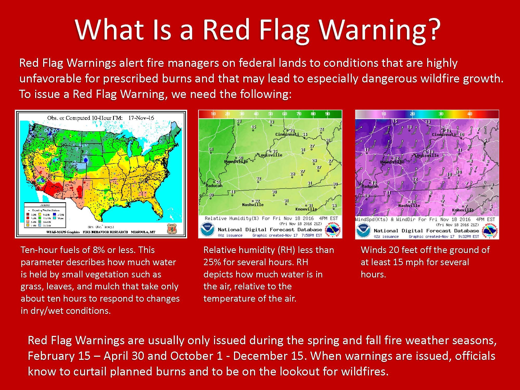
What is a Red Flag Warning?
A Red Flag Warning means warm temperatures, very low humidities, and stronger winds are expected to combine to produce an increased risk of fire danger.
If you are allowed to burn in your area, all burn barrels must be covered with a weighted metal cover, with holes no larger than 3/4 of an inch.
Do not throw cigarettes or matches out of a moving vehicle. They may ignite dry grass on the side of the road and become a wildfire.
Extinguish all outdoor fires properly. Drown fires with plenty of water and stir to make sure everything is cold to the touch. Dunk charcoal in water until cold. Do not throw live charcoal on the ground and leave it.
Never leave a fire unattended. Sparks or embers can blow into leaves or grass, ignite a fire, and quickly spread.

The 2022 Summer Weather Alerts are brought to you by Country Financial, Cora Christ
Insurance coverage that grows with your family, farm, or business.
COUNTRY Financial, Cora Christ
3815 South Sixth Street, Suite 130, Klamath Falls, OR 97603
541-882-3921