

Red Flag Warnings issued for 4th straight day
/
Abundant Lightning On Dry Fuels Expected through Monday
MEDFORD, Ore. - While cloud cover and showers along and near the Cascades this morning will limit the potential for thunderstorm development in that area for much of the afternoon, areas west and east of that cloud cover are likely to see thunderstorms develop this afternoon.
This evening through early Tuesday morning an upper-level impulse moving northward from the San Francisco Bay area is expected to increase shower and thunderstorm coverage across the forecast area, including some areas west of the Cascades.
After a brief lull late Tuesday morning into early Tuesday afternoon, a new round of scattered showers and thunderstorms is expected to develop from western Siskiyou County, Josephine County, and eastern Douglas County eastward. Abundant lightning, gusty outflow winds, and locally heavy rainfall are all possible with thunderstorms.
Fire Weather Warnings for August 2, 2022
RED FLAG WARNING
URGENT - WINTER WEATHER MESSAGE
National Weather Service Medford OR
441 PM PDT Sun Jul 31 2022
Western Rogue Basin
Western Klamath National Forest
Siskiyou County
Modoc County
Siskiyou Mountains
Eastern Rogue Valley
Southern Oregon Cascades
Klamath Basin
Fremont Winema National Forest
South Central Oregon Desert
Lake County
Harney County
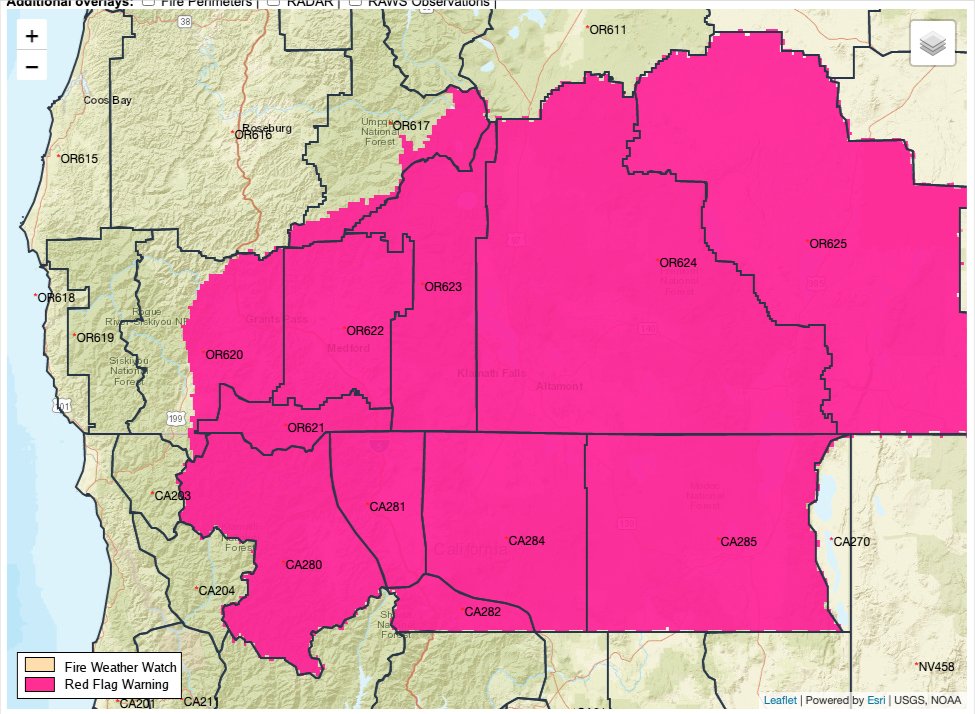
RED FLAG WARNING REMAINS IN EFFECT UNTIL 11 PM PDT THIS EVENING FOR ABUNDANT LIGHTNING ON DRY FUELS FOR FIRE WEATHER ZONES: 280, 281, 282, 284, 285, 620, 621, 622,623, 624, 625
IMPACTS:
Abundant lightning on critically dry vegetation is likely to result in numerous new fire starts this afternoon through Tuesday evening that could overwhelm firefighting resources. Gusty thunderstorm outflow wind gusts of 30 to 60 mph will contribute to fire spread in some areas. In other areas, locally heavy, wetting rainfall is likely to limit or prevent fire spread, but numerous holdover fires will be possible.
A Red Flag Warning means that critical fire weather conditions are either occurring now or will shortly. These conditions promote rapid spread of fire which may become life threatening. Evacuate if ordered to, or if a fire threatens.

Abundant lightning on critically dry vegetation is likely to result in numerous new fire starts this afternoon through Tuesday evening that could overwhelm firefighting resources. Gusty thunderstorm outflow wind gusts of 30 to 60 mph will contribute to fire spread in some areas. In other areas, locally heavy, wetting rainfall is likely to limit or prevent fire spread, but numerous holdover fires will be possible.

It’s good to be weather aware. A good place to start is knowing what a Red Flag Warning means. Which is conditions where new fires can start due to abundant lightning or where hot, dry, windy conditions can cause fires to rapidly spread are immanent or ongoing. It is best to be ready to go immediately in case a fire causes you to need to evacuate.
What is a Red Flag Warning?
A Red Flag Warning means warm temperatures, very low humidities, and stronger winds are expected to combine to produce an increased risk of fire danger.
If you are allowed to burn in your area, all burn barrels must be covered with a weighted metal cover, with holes no larger than 3/4 of an inch.
Do not throw cigarettes or matches out of a moving vehicle. They may ignite dry grass on the side of the road and become a wildfire.
Extinguish all outdoor fires properly. Drown fires with plenty of water and stir to make sure everything is cold to the touch. Dunk charcoal in water until cold. Do not throw live charcoal on the ground and leave it.
Never leave a fire unattended. Sparks or embers can blow into leaves or grass, ignite a fire, and quickly spread.

The 2022 Summer Weather Alerts are brought to you by Country Financial, Cora Christ
Insurance coverage that grows with your family, farm, or business.
COUNTRY Financial, Cora Christ
3815 South Sixth Street, Suite 130, Klamath Falls, OR 97603
541-882-3921