

Red Flag Warning issued, abundant lightning on dry fuels expected through Monday
/
Abundant lightning on dry fuels expected through Monday
MEDFORD, Ore. - Heat, instability, and increasing moisture along with multiple low pressure impulses moving through Monday are expected to bring scattered thunderstorms and abundant lightning on dry fuels to the area. Today into Monday, an approaching low pressure system will bring more abundant lightning to areas from the Marble Mountains and Siskiyous northeastward.

Red Flag Warning for July 31, 2022
RED FLAG WARNING
URGENT - WINTER WEATHER MESSAGE
National Weather Service Medford OR
503 AM PDT Sun Jul 31 2022
Western Klamath National Forest
Central Siskiyou County including Shasta Valley
Siskiyou County from the Cascades east and south to Mt Shasta
Umpqua National Forest
Southern Oregon Cascades
Klamath Basin
Fremont Winema National Forest
...RED FLAG WARNING REMAINS IN EFFECT FROM 2 PM THIS AFTERNOON TO 11 PM PDT THIS EVENING FOR ABUNDANT LIGHTNING ON DRY FUELS FOR FIRE WEATHER ZONES 281 AND 624...
...FIRE WEATHER WATCH REMAINS IN EFFECT FROM MONDAY MORNING THROUGH MONDAY EVENING FOR ABUNDANT LIGHTNING ON DRY FUELS FOR FIRE WEATHER ZONES 281 AND 624...
The National Weather Service in Medford has issued a Red Flag Warning...which is in effect from 2 PM this afternoon to 8 PM PDT this evening.
Impacts:
Lightning and high fire danger will likely result in new fire starts. Gusty thunderstorm winds could contribute to fire spread. Despite rainfall, initial attack resources could be overwhelmed and holdover fires are possible.
Affected area:
In Northern CA Fire Zones...280...281...284.
In South Central OR Fire Zone....624.
In Southwest OR Fire Zones...617...623.
Thunderstorms:
Today into Monday, an approaching low pressure system will bring a couple of rounds of scattered thunderstorms.
Rainfall:
Today, thunderstorms may begin relatively dry and then transition to a mix of wet and dry. Monday, thunderstorms are more likely to produce wetting rainfall. Locally significant wetting rainfall will be possible with some of the thunderstorms, especially the slower moving ones.
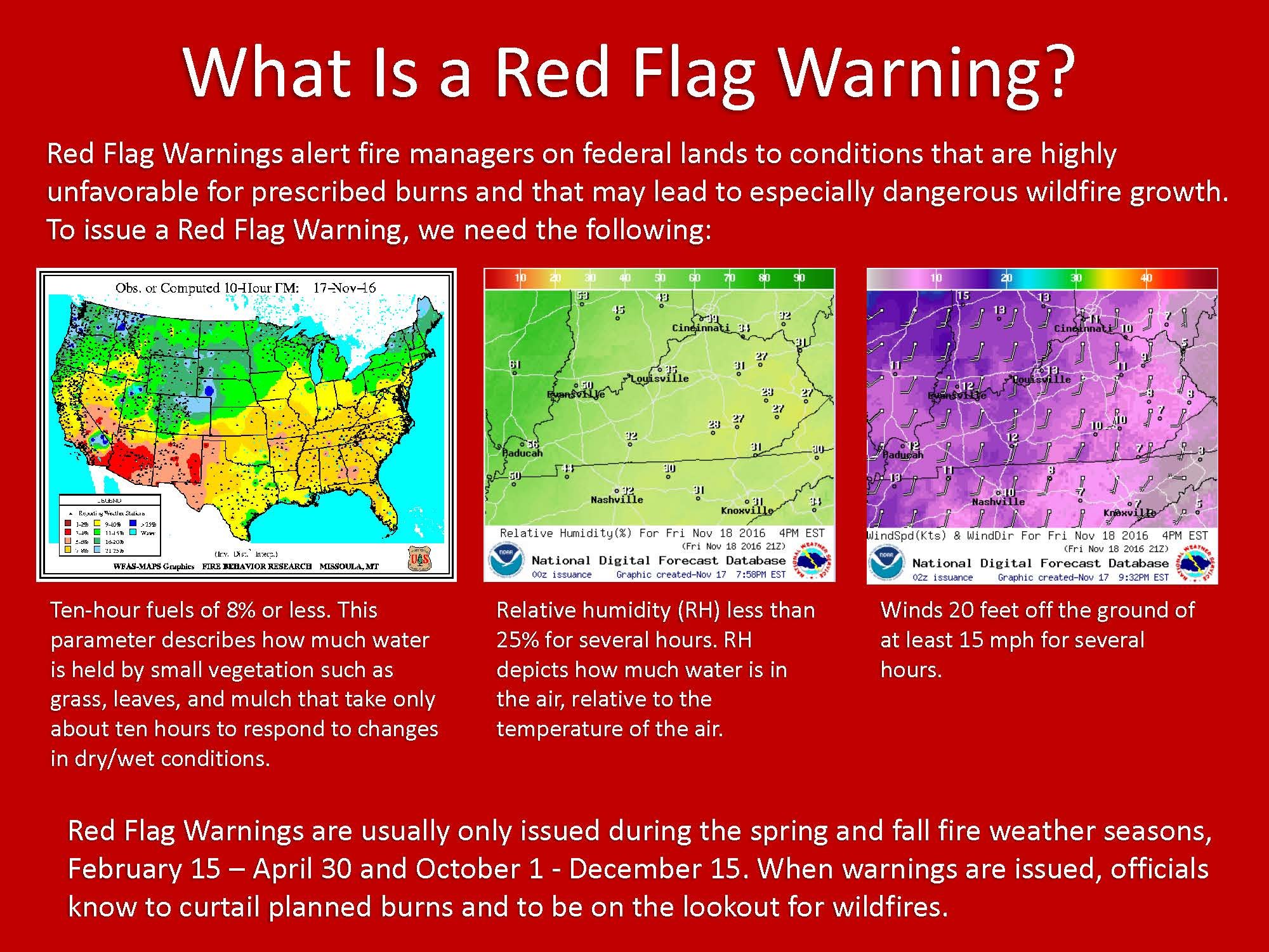
What is a Red Flag Warning?
A Red Flag Warning means warm temperatures, very low humidities, and stronger winds are expected to combine to produce an increased risk of fire danger.
If you are allowed to burn in your area, all burn barrels must be covered with a weighted metal cover, with holes no larger than 3/4 of an inch.
Do not throw cigarettes or matches out of a moving vehicle. They may ignite dry grass on the side of the road and become a wildfire.
Extinguish all outdoor fires properly. Drown fires with plenty of water and stir to make sure everything is cold to the touch. Dunk charcoal in water until cold. Do not throw live charcoal on the ground and leave it.
Never leave a fire unattended. Sparks or embers can blow into leaves or grass, ignite a fire, and quickly spread.

The 2022 Summer Weather Alerts are brought to you by Country Financial, Cora Christ
Insurance coverage that grows with your family, farm, or business.
COUNTRY Financial, Cora Christ
3815 South Sixth Street, Suite 130, Klamath Falls, OR 97603
541-882-3921