

Red Flag Warning Extended until Monday
/
This winter weather alert is courtesy Cora Christ, Country Financial, 541-882-3921.
Gusty winds with low relative humidity Sunday and Monday.
MEDFORD, Ore. - An upper level trough will pass to our north today. This trough will produce gusty winds this afternoon and Monday afternoon, that when combined with very low relative humidities, will likely result in critical fire weather conditions.

Fire weather map for July 17, 2022 - https://www.weather.gov/wrh/fire?wfo=mfr
RED FLAG WARNING
URGENT - WINTER WEATHER MESSAGE
National Weather Service Medford OR
114 AM PDT Sun Jul 17 2022
Siskiyou County / Klamath Basin / South Central Oregon Desert / Lake County / Harney County
INCLUDING:
Adel, Alturas, Beatty, Bly, Canby, Cedarville, Davis Creek, Fort Bidwell, Lakeview, New Pine Creek, Plush, Valley Falls - Fremont-Winema National Forest, Hart Mountains, Modoc National Forest, Warner Mountains.
FIRE ZONES: 284, 624, 625
RED FLAG WARNING REMAINS IN EFFECT FROM 2:00 PM THIS AFTERNOON TO 9:00 PM PDT THIS EVENING FOR STRONG GUSTY WIND WITH LOW RH FOR FIRE WEATHER ZONES 284, 624, AND 625
FIRE WEATHER WATCH REMAINS IN EFFECT FROM MONDAY AFTERNOON THROUGH MONDAY EVENING FOR STRONG GUSTY WIND WITH LOW RH FOR FIRE WEATHER ZONE 285
Impacts: Strong, gusty wind with low relative humidity and critically dry vegetation will greatly increase the spread potential of any new and existing fires.
Affected area:
In Northern California: Eastern Fire Zone 284, including portions of Lava Beds National Monument and the Modoc National Forest.
In South Central Oregon: Southern Fire Zone 624, including Lakeview, Valley Falls, the Warner Mountains, and portions of the Fremont-Winema National Forest. And Fire Zone 625, including Adel, the Hart Mountains, and the Hart Mountain Antelope Refuge.
Wind: Southwest 10 to 20 mph with gusts up to 40 mph.
Humidity: 5 to 10 percent.
A Red Flag Warning does not mean there is a fire. It means that critical fire weather conditions are either occurring now or will shortly. These conditions promote rapid spread of fire which may become life threatening. Evacuate if ordered to, or if a fire threatens.
Plan now to avoid using equipment that could cause sparks during the period when critical weather conditions are possible. Visit weather.gov/medford/wildfire for links to fire restrictions in your area.

Dry, and breezy conditions will continue through the weekend with gusty winds expected from around mid afternoon through early in the evening. Red Flag Warnings have been issued for areas east of the Cascades. Some things to consider for wildfire safety: Properly discard cigarettes, keep vehicles off of dry grass, avoid activities with open flames or sparks, and avoid power equipment that creates sparks.
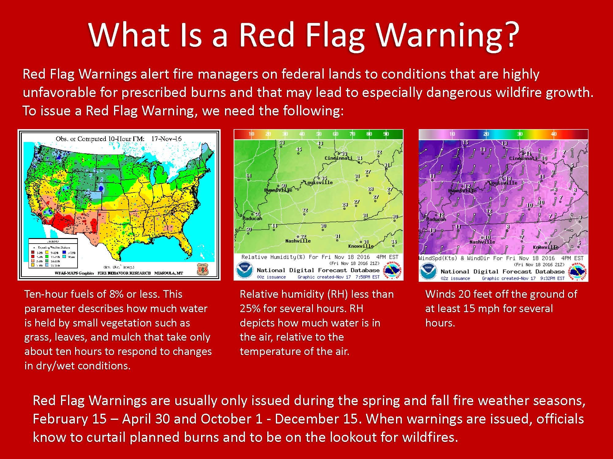
What is a Red Flag Warning?
A Red Flag Warning means warm temperatures, very low humidities, and stronger winds are expected to combine to produce an increased risk of fire danger.
If you are allowed to burn in your area, all burn barrels must be covered with a weighted metal cover, with holes no larger than 3/4 of an inch.
Do not throw cigarettes or matches out of a moving vehicle. They may ignite dry grass on the side of the road and become a wildfire.
Extinguish all outdoor fires properly. Drown fires with plenty of water and stir to make sure everything is cold to the touch. Dunk charcoal in water until cold. Do not throw live charcoal on the ground and leave it.
Never leave a fire unattended. Sparks or embers can blow into leaves or grass, ignite a fire, and quickly spread.

The 2022 Summer Weather Alerts are brought to you by Country Financial, Cora Christ
Insurance coverage that grows with your family, farm, or business.
COUNTRY Financial, Cora Christ
3815 South Sixth Street, Suite 130, Klamath Falls, OR 97603
541-882-3921